Capulin Volcano
Elevation: 2494 m / 8182 ft
New Mexico
Datum: December 01, 2013

Age: 9 million years to 40,000 years
Significance:
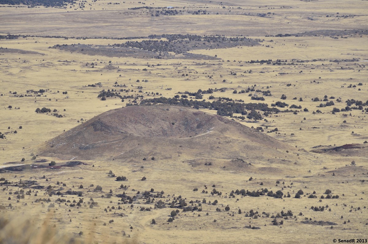
 Capulin ( New Mexico) and Paricutin (
Michoacán, Mexico) volcanoes. (above)
Capulin ( New Mexico) and Paricutin (
Michoacán, Mexico) volcanoes. (above)
The similarity between Capulin and Paricutin volcanoes is striking. In
addition to the size and general morphology of the cones, both cones developed
large “bocas” or flows that emerge from one flank, that ramp up onto the cone
flanks in approximately the same way and spread lava flows in much the same
way. A large lava channel on the Paricutin boca is similar to the channel that
today is the picnic area at Capulin. However, Capulin Volcano National Monument
was created decades before Paricutin erupted. In fact, Paricutin erupted in a
Mexican farmer’s cornfield in 1943, 60,000 years after Capulin.


Expanded
Discussion about the Raton-Clayton field


Phases of Volcanic Activity
(Stratigraphy) in the Raton-Clayton Volcanic Field

General Reference Information
Petrology/ General
Geology:
All text credit due to
Dr. Larry Crumpler, New Mexico Museum of Natural History and Science.
View Raton-Clayton Volcanic Field in a larger map Album sa slikama:
Elevation: 2494 m / 8182 ft
New Mexico
Datum: December 01, 2013
Raton-Clayton Volcanic Field: Capulin Volcano

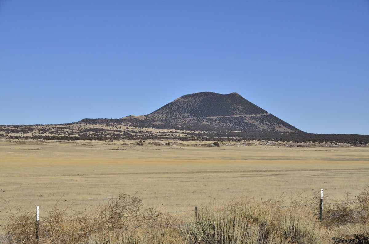
Capulin Volcano, December 2013
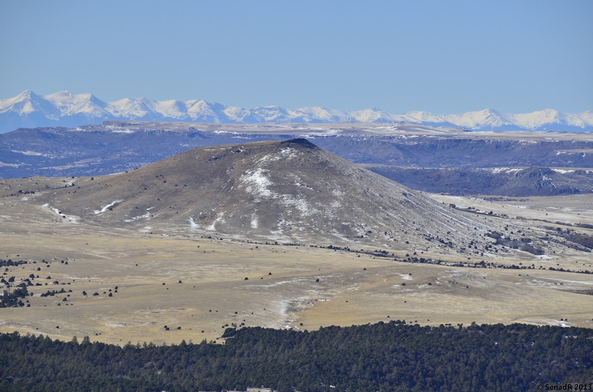
The
most recent volcanic activity occurred at several volcanoes in the center of
the field in the vicinity of Capulin Mountain, where lava flows moved down what
are essentially modern drainages. Recent work by geologists from College of
Santa Fe and Northern Arizona University, in conjunction with the Park Service
(Sayre et al, 1995; Stroud, 1996), has resulted in new age dates indicating
that Capulin Mountain erupted approximately 56,000 to 62,000 years ago,
somewhat earlier than the reported age of the famed Folsom paleosite (~11,000
years ago). Capulin Mountain is a classic cinder cone with associated small
volumes of lavas flows. It is similar in size and morphology, and probably
eruptive characteristics, to Paricutin volcano, Mexico which erupted in 1943.
+700.jpg) |
Capulin VolcanoPhoto Taken by Dr. Larry Crumpler |
Location: 36 to 37.3° N latitude, 103.1 to 104.3° W longitude, Union County
Type: Extensive volcanic field of scoria cones, silicic volcanoes, and lava flowsAge: 9 million years to 40,000 years
Significance:
Large and young monogenetic scoria cones; extreme diversity of lava compositions from very mafic to dacitic.
A detailed study of Capulin (Ort, 1997), indicates that a complicated series of lava flows and cinder/spatter eruptions occurred, during or after eruption of the cinder cone, in order to build Capulin Volcano. Three major series of lava flow units occurred, the earliest flowed to the east-southeast of the cone, the second to the west and south, and the third to the west and north. The second and third series of flows were erupted from an area at the base of the cone called the boca (mouth) and during these eruptions several intermittent lava lakes formed at the lower flanks of the volcano and portions of the cone were “rafted” away on the surface of the flows.
Capulin ( New Mexico) and Paricutin (
Michoacán, Mexico) volcanoes. (above)
The similarity between Capulin and Paricutin volcanoes is striking. In
addition to the size and general morphology of the cones, both cones developed
large “bocas” or flows that emerge from one flank, that ramp up onto the cone
flanks in approximately the same way and spread lava flows in much the same
way. A large lava channel on the Paricutin boca is similar to the channel that
today is the picnic area at Capulin. However, Capulin Volcano National Monument
was created decades before Paricutin erupted. In fact, Paricutin erupted in a
Mexican farmer’s cornfield in 1943, 60,000 years after Capulin.


Expanded
Discussion about the Raton-Clayton field
The Raton-Clayton volcanic
field lies at the northeastern end of the "Jemez lineament", a
prominent alignment of volcanic fields extending from the Pinacate field of
Mexico, through the Springerville field on the southern margin of the Colorado
Plateau in eastern Arizona, the Zuni-Bandera field, the Mount Taylor field, the
Jemez field, and Cerros del Rio Field, and terminating in the northeastern
corner of New Mexico in the Raton-Clayton field (Figure 1A & B). Some
studies also include the Taos volcanic field as part of the general trend as
well. In fact, the Taos field bears many similarities with the Raton-Clayton
field in terms of age, morphology of silicic vents, and compositions. Because
the alignment of fields in the Jemez lineament is parallel to the Snake
River-Yellowstone hotspot track, the Jemez Lineament also has been considered
by some to be a type of hot spot. As such the Raton-Clayton "hot
spot" is one of only 49 hot spots identified on Earth. It should be
clarified that the status as a true hot spot is not clear-cut largely because
there is no strong age progression, for example, from southwest to northeast,
as is typical of true hot spot tracks.

There
are many volcanic fields of late Cenozoic age throughout the Southwest, each of
which is distinctive in terms of the details of petrology, timing of eruptions,
size, and morphology of vents, and character of pyroclastic deposits. But
overall, they are all characterized by many small centers of eruption (one to a
few kilometers across) of fundamentally basaltic, but ranging to more silicic,
compositions. Instead of one big volcano, volcanic fields are typically on the
order of one hundred kilometers across, and contain from several tens of vents
to several hundred volcanic vents erupted over a period of several million
years. Volcanic fields also differ from single large volcanoes, like Hawaii or
the large volcanoes of the Cascades. They are also characterized by low rates
of magma eruption, typically an order of magnitude less than large volcanoes.

The
Raton-Clayton field is elongated northwest-southeast, the axis extending from
near Trinidad, Colorado, 140 km southeastward to Clayton, New Mexico (Dungan,
et al, 1989). Including the outlying parts, the field covers nearly 20,000 km2
(Figure 3) (Stormer, 1987; Muehlberger, et al, 1967). The oldest rocks range
from about 9 Ma and the youngest erupted less than 60,000 years ago (Sayre et
al, 1995; Stroud, 1996). The distinctive characteristic of the Raton-Clayton
field is the presence of highly alkalic mafic lavas with SiO2 contents as low
as 36%. However, the field also contains centers, such as Sierra Grande, that erupted
andesite, dacite or rhyodacite (up to nearly 70% SiO2).


Phases of Volcanic Activity
(Stratigraphy) in the Raton-Clayton Volcanic Field
Traditionally the RCVF has been divided into three main
phases of volcanic activity (Baldwin and Muehlberger, 1959; Muehlberger, et al,
1967). As a result of recent age radiometric determinations (Stroud, 1996), the
ages of these phases are now known to be older than reported in earlier
published accounts. Nonetheless, the basic stratigraphy remains adequately
defined by three periods. (Note: The following is from Mathis, 1997.)
Raton Phase 9.0 - 3.5 Ma
Clayton Phase 3.0 -2.25 Ma
Capulin Phase 1.7 - 0.04 Ma

These
are defined in part by a sequence of inverted topography in which the older
units are situated on earlier and now higher erosion surfaces, and subsequent
eruptions were emplaced on younger and lower surfaces.The earliest lavas of the
Raton-Clayton field flowed onto the surface of an alluvial apron of sediment
shed eastward from the Sangre de Cristo Mountains (which are to the west of the
field) (Baldwin and Muehlberger, 1959; Dungan, et al, 1989). Continuing uplift
during eruption resulted in the erosion of this surface where it was not capped
by volcanic rocks. During subsequent eruptions, lava flowed down valleys cut
into this surface. The result is a series of "inverted topographic
valleys" such that the oldest volcanic rocks are generally found at the
highest elevations above present erosional levels, with younger lavas at
progressively lower levels and in modern drainages. Thus the field is
characterized by a kind of inverted stratigraphy.

The
rate of downcutting has been significantly greater in the western part of the
field along the head of valleys draining into the Canadian River. The high,
lava-capped mesas in the distance to the north are over 700 m above the valley
floor. To the east, the elevation of the older basalt-capped mesas decreases,
and at Clayton they are only a few meters above the present valley floors.

General Reference Information
Petrology/ General
Geology:
- · Baldwin, B. and Muehlberger, W.R., 1959. Geologic Studies of Union County, NM, Bull. 63, NM Bur. Mines and Min. Res., 171 p.
- · Dungan, M.A., R. A. Thompson, and J. S. Stormer, 1989. Rio Grande Rift volcanism: Northeastern Jemez zone, New Mexico. Field Excursions to volcanic terranes in the western United States, Vol 1: Southern Rocky Mountain Region, Memoir 46, NM Bureau Mines Min. Res., p. 474-475.
- · Mathis, A., 1997. Geologist/Park Ranger at Capulin Volcano National Monument, personal communication and unpublished park interpretive materials.
- · Muehlberger, W.R., Baldwin, B., and Foster, R.W., 1967. High plains northeastern NM: Scenic Trips to the Geologic Past, no. 7: NM Bur. of Mines and Min. Res., 107p.
- · Ort, M., 1997. Northern Arizona University, personal communication and unpublished map and manuscript.
- · Sayre, W.O, Ort, M.H. and Graham, D., 1995. Capulin Volcano: Park Science, v.15, n.2, p.10-11.
- · Stormer, J.C., 1987. Capulin Mountain Volcano and RCVF, northeastern New Mexico: Geol. Soc. of America Centennial Field Guide, Vol. 2, Rocky Mountain Section, 421-424.
All text credit due to
Dr. Larry Crumpler, New Mexico Museum of Natural History and Science.
View Raton-Clayton Volcanic Field in a larger map Album sa slikama:


1 komentari:
Very good information. Lucky me I recently found your
website by chance (stumbleupon). I've book marked it for later!
Look into my webpage get free facebook likes (realfansfast.com)
Objavi komentar